
Bestand:Antarctica Map.png

Grootte van deze voorvertoning: 488 × 600 pixels. Andere resoluties: 195 × 240 pixels | 502 × 617 pixels.
Oorspronkelijk bestand (502 × 617 pixels, bestandsgrootte: 52 kB, MIME-type: image/png)
Dit is een bestand van Wikimedia Commons. Onderstaande beschrijving komt van de beschrijving van het bestand daar.
Commons is een vrij-gelicenceerde database voor afbeeldingen, geluid, video en andere bestanden. |
- Deutsch: Karte der Antarktis
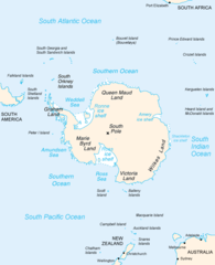
- English: Map of Antarctica
- Español: Mapa de la Antártida
- Polski: Mapa Antarktydy
- For a French version, see : Image:Antarctique_carte.png
- For an German version, see : Image:Antarctica_Karte.png
Deze afbeelding bevindt zich in het publiek domein omdat het materiaal bevat dat oorspronkelijk afkomstig is van het CIA World Factbook.
|
 |
derivative works
Afgeleide werken van dit bestand: Map-antarctica-ross-ice-shelf-red-x.png
Bestandsgeschiedenis
Klik op een datum/tijd om het bestand te zien zoals het destijds was.
| Datum/tijd | Miniatuur | Afmetingen | Gebruiker | Opmerking | |
|---|---|---|---|---|---|
| huidige versie | 16 dec 2004 01:16 | | 502 × 617 (52 kB) | Mschlindwein |
Bestandsgebruik
Dit bestand wordt op de volgende pagina gebruikt:
Globaal bestandsgebruik
De volgende andere wiki's gebruiken dit bestand:
- Gebruikt op an.wikipedia.org
- Gebruikt op ar.wikipedia.org
- Gebruikt op avk.wikipedia.org
- Gebruikt op azb.wikipedia.org
- Gebruikt op be.wikipedia.org
- Gebruikt op bjn.wikipedia.org
- Gebruikt op blk.wikipedia.org
- Gebruikt op bn.wikipedia.org
- Gebruikt op br.wikipedia.org
- Gebruikt op bs.wikipedia.org
- Gebruikt op ca.wikipedia.org
- Gebruikt op cs.wikipedia.org
- Gebruikt op da.wikipedia.org
- Gebruikt op de.wikinews.org
- Gebruikt op en.wikipedia.org
- Filchner–Ronne Ice Shelf
- Palmer Land
- Frost Glacier
- Second German Antarctic Expedition
- Totten Glacier
- Wikipedia:WikiProject Antarctica
- Polynesian navigation
- Underwood Glacier
- Farthest South
- Adams Glacier (Wilkes Land)
- Ocean fisheries
- 80th parallel south
- Southern Ocean
- Dibble Iceberg Tongue
- Gilchrist Glacier
- Peterson Glacier
- Bell Glacier
- Blair Glacier
- Blodgett Iceberg Tongue
- Bond Glacier
- Bibliography of Antarctica
- Conger Glacier
- Waldron Glacier
- Whittle Glacier
Globaal gebruik van dit bestand bekijken.