
Bestand:Gz-map.png
Geen hogere resolutie beschikbaar.
Gz-map.png (330 × 354 pixels, bestandsgrootte: 13 kB, MIME-type: image/png)
Dit is een bestand van Wikimedia Commons. Onderstaande beschrijving komt van de beschrijving van het bestand daar.
Commons is een vrij-gelicenceerde database voor afbeeldingen, geluid, video en andere bestanden. |
Beschrijving
| Beschrijving |
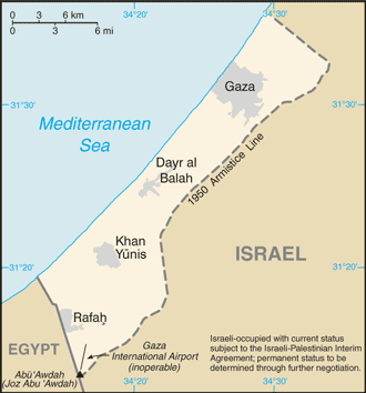
English: A map of the Gaza Strip showing key towns and neighbouring countries. |
|||
| Bron | Gaza Strip from CIA factbook | |||
| Auteur | CIA | |||
| Andere versies |
[] Ver1:
Ver2:
|


Licentie
Deze afbeelding bevindt zich in het publiek domein omdat het materiaal bevat dat oorspronkelijk afkomstig is van het CIA World Factbook.
|
 |
Bestandsgeschiedenis
Klik op een datum/tijd om het bestand te zien zoals het destijds was.
| Datum/tijd | Miniatuur | Afmetingen | Gebruiker | Opmerking | |
|---|---|---|---|---|---|
| huidige versie | 12 dec 2008 12:24 | | 330 × 354 (13 kB) | Mattflaschen | Put back latest image from Factbook. This includes the note (don't know whether it was there on December 2, 2007). |
| 2 dec 2007 04:17 |  | 328 × 352 (8 kB) | Kordas | Updated map | |
| 15 aug 2005 20:12 |  | 328 × 352 (10 kB) | Mrmiscellanious~commonswiki | A map of the Gaza Strip showing key towns and neighbouring countries. Taken from CIA World Factbook website on 15 August 2005. Public domain, as is all content from the CIA factbook. | |
| 15 sep 2004 14:37 |  | 330 × 355 (9 kB) | Robbot | This image was copied from en.wikipedia.org. The original description was: A map of the Gaza Strip showing key towns and neighbouring countries. Taken from CIA World Factbook website on 12 April. Public domain, as is all content from |
Bestandsgebruik
Dit bestand wordt op de volgende pagina gebruikt:
Globaal bestandsgebruik
De volgende andere wiki's gebruiken dit bestand:
- Gebruikt op be.wikipedia.org
- Gebruikt op bn.wikipedia.org
- Gebruikt op br.wikipedia.org
- Gebruikt op bs.wikipedia.org
- Gebruikt op bs.wikinews.org
- Gebruikt op ca.wikipedia.org
- Gebruikt op cs.wikinews.org
- Gebruikt op da.wikipedia.org
- Gebruikt op de.wikinews.org
- Gebruikt op en.wikipedia.org
- Gebruikt op en.wikinews.org
- Israeli army kills three Egyptians in border incident
- Abbas wins election, offers Israel 'hand of peace'
- Wikinews:2005/January
- Wikinews:2005/January/13
- K'nesset Member Natan Sharansky resigns from coalition government to protest planned Gaza withdrawal
- Israeli Air Force attacks targets in Gaza
- Israeli greenhouses to be preserved after Gaza pullout
- Gaza Strip pullout under way
- Israeli Army begins forced evacuation of Gaza settlements
- Palestinian gunmen assassinate ex-security chief
- Israel completing Gaza withdrawal
- Israel Defense Forces attack Gaza Strip
- Israel releases 90 Palestinian prisoners
- Israeli air strikes hit government compounds in Gaza
- Palestinian president pleads with UN Security Council for help in Gaza
- Gebruikt op en.wikivoyage.org
- Gebruikt op eo.wikipedia.org
- Gebruikt op es.wikipedia.org
- Gebruikt op es.wikinews.org
- Gebruikt op eu.wikipedia.org
- Gebruikt op fr.wikipedia.org
- Gebruikt op fr.wikinews.org
- Gebruikt op gl.wikipedia.org
- Gebruikt op he.wikipedia.org
- Gebruikt op he.wikinews.org
- Gebruikt op hr.wikipedia.org
Globaal gebruik van dit bestand bekijken.