Naar inhoud springen

Bestand:America noviter delineata.jpg
Pagina-inhoud wordt niet ondersteund in andere talen.
Uit Wikivoyage

Oorspronkelijk bestand(5.965 × 4.528 pixels, bestandsgrootte: 5,17 MB, MIME-type: image/jpeg)

Beschrijving

Beschrijving
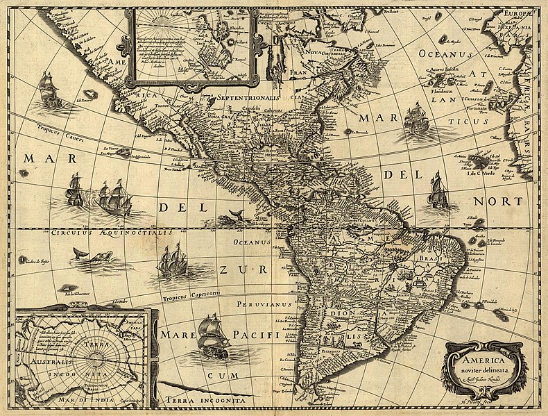
Latina: America noviter delineata / auct. Jodoco Hondio; H. Picard fecit.
English: America newly delineated / by Jodocus Hondius; engraved by H. Picard. A 17th-century map of the Americas. Scale ca. 1:45,000,000. Map ranges from W 125°–W 5° and N 70°–S 60°. Also includes insets of the polar regions.
Français : L'amérique nouvellement cartographiée / Par Jocodus Hondius; gravé par H. Picard. Une carte des amériques du XVIIe siècle. Echelle: environ 1:45 000 000. La carte couvre un espace allant de 5°W à 125°W et de 60°S à 70°N. Elle inclut aussi en encarts les régions polaires.
Bron

Published by Jean Boisseau. The U.S. Library of Congress gives the date of publication as "1640?", while another source suggests a first publication of 1637 or 1639. Digital version produced by the U.S. Library of Congress Geography and Map Division. JPEG 2000 source image converted to JPEG by User:Delirium using JasPer 1.701.0, since JPEG 2000 is not as of this uploading supported on Commons.

Dit bestand is beschikbaar in de Geography & Map Division van de Library of Congress
via digitaal ID g3290.np000144.
Deze banner zegt niets over de auteursrechten die van toepassing zijn. Een normale auteursrechten-tag is nodig. Zie Commons:Licensing voor meer informatie.

العربية  беларуская (тарашкевіца)  বাংলা  čeština  Deutsch  English  español  فارسی  suomi  français  galego  עברית  magyar  Bahasa Indonesia  italiano  日本語  lietuvių  македонски  മലയാളം  Nederlands  polski  português  português do Brasil  română  русский  sicilianu  slovenčina  slovenščina  Türkçe  українська  简体中文  繁體中文  +/−

Maker
Jodocus Hondius (1563-1612)
Toestemming
(Hergebruik van dit bestand)
Het tweedimensionale kunstwerk afgebeeld op deze afbeelding valt in het publiek domein omdat:
Public domain

Dit werk bevindt zich in het publiek domein in landen en gebieden waar de auteursrechttermijn het leven van de auteur plus 100 jaar of minder is.


Je dient ook een Amerikaans publiek domein-tag in te voegen om aan te geven waarom dit werk zich in het publiek domein bevindt in de Verenigde Staten.
Reproducties van het werk kunnen ook worden beschouwd als publiek domein omdat ze geen oorspronkelijk karakter hebben. Dit geldt voor reproducties gemaakt in de Verenigde Staten (zie Bridgeman Art Library v. Corel Corp.), Duitsland en veel andere landen.
Georeferencing Georeference the map in Wikimaps Warper If inappropriate please set warp_status = skip to hide.


Awards

Afbeelding of the year
Afbeelding van de dag
Uitgelichte afbeelding

Wikimedia Commons

Dit bestand was een kandidaat bij Afbeelding van het jaar 2006.
Dit bestand was Afbeelding van de dag op (en) , 1.
Dit is een uitgelichte afbeelding op Wikimedia Commons (Uitgelichte afbeeldingen) en wordt beschouwd als een van de beste afbeeldingen.
 Vanwege de aspect ratio van 4:3 of 5:4 is deze afbeelding geschikt als bureaubladachtergrond (zie galerij).

Als u een bestand van vergelijkbare kwaliteit heeft dat kan worden gepubliceerd onder een geschikte copyrightlicentie, upload het dan, voeg een licentie toe, en nomineer het.

Bijschriften

Beschrijf in één regel wat dit bestand voorstelt
A 17th-century map of the Americas newly delineated by Jodocus Hondius; engraved by H. Picard.

Items getoond in dit bestand

beeldt af

image/jpeg

5ad48d30d4daf7c752e21a8ff169415effca1831

5.422.959 byte

4.528 pixel

5.965 pixel

Bestandsgeschiedenis

Klik op een datum/tijd om het bestand te zien zoals het destijds was.

Datum/tijdMiniatuurAfmetingenGebruikerOpmerking
huidige versie14 jun 2006 08:33Miniatuurafbeelding voor de versie van 14 jun 2006 08:335.965 × 4.528 (5,17 MB)Delirium''America noviter delineata / auct. Jodoco Hondio; H. Picard fecit.'' (America newly delineated / by Jodoco Hondia; engraved by H. Picard.) A 17th-century map of the Americas. Scale ca. 1:45,000,000. Map ranges from W 125°–W 5° and N 70&d

Geen enkele pagina gebruikt dit bestand.

Globaal bestandsgebruik

De volgende andere wiki's gebruiken dit bestand:

Globaal gebruik van dit bestand bekijken.

Metadata