
Bestand:Map of the western Florida Keys, from the Dry Tortugas to Little Torch Key, showing boundaries of National Marine Sanctuaries 2000.jpg

Grootte van deze voorvertoning: 783 × 600 pixels. Andere resoluties: 313 × 240 pixels | 627 × 480 pixels | 1.003 × 768 pixels | 1.280 × 980 pixels | 1.957 × 1.499 pixels.
Oorspronkelijk bestand (1.957 × 1.499 pixels, bestandsgrootte: 484 kB, MIME-type: image/jpeg)
Dit is een bestand van Wikimedia Commons. Onderstaande beschrijving komt van de beschrijving van het bestand daar.
Commons is een vrij-gelicenceerde database voor afbeeldingen, geluid, video en andere bestanden. |
Beschrijving
| Beschrijving |
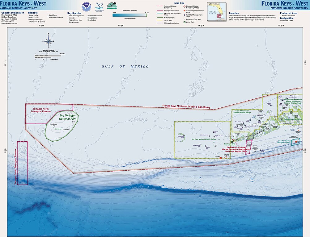
English: Map of the Florida Keys, showing National Marine Sanctuaries |
| Datum | |
| Bron | http://sanctuaries.noaa.gov/pgallery/atlasmaps/fkwest.html |
| Auteur | Sanctuaries Web Team of National Ocean Service of National Oceanic and Atmospheric Administration of U.S. Department of Commerce |
| Toestemming (Hergebruik van dit bestand) |
U.S. Federal Government work, therefore public domain |
Licentie
Deze afbeelding is in het publiek domein omdat het materiaal bevat dat oorspronkelijk van de National Oceanic and Atmospheric Administration kwam in de Verenigde Staten en genomen of gemaakt is tijdens de officiële werkzaamheden van een werknemer.
|
Oorspronkelijk uploadlogboek
De oorspronkelijke beschrijving van deze afbeelding stond 2000.jpg hier. Alle volgende gebruikersnamen verwijzen naar en.wikipedia.
- 2008-11-16 17:32 Nricardo 2000×1550× (406095 bytes) {{Information |Description=Map of the Florida Keys, showing National Marine Sanctuaries |Source=http://sanctuaries.noaa.gov/pgallery/atlasmaps/fkwest.html |Date=2008-11-16 |Author=Sanctuaries Web Team of National Ocean Service of National Oceanic and Atm
Bestandsgeschiedenis
Klik op een datum/tijd om het bestand te zien zoals het destijds was.
| Datum/tijd | Miniatuur | Afmetingen | Gebruiker | Opmerking | |
|---|---|---|---|---|---|
| huidige versie | 29 jul 2017 10:57 | | 1.957 × 1.499 (484 kB) | ديفيد عادل وهبة خليل 2 | Removed border by cropping 2 % horizontally and 3 % vertically using CropTool with precise mode. |
| 26 apr 2009 12:34 |  | 2.000 × 1.550 (397 kB) | Urdangaray | {{Information |Description={{en|Map of the Florida Keys, showing National Marine Sanctuaries}} |Source=Transferred from [http://en.wikipedia.org en.wikipedia]<br/> (Original text : ''http://sanctuaries.noaa.gov/pgallery/atlasmaps/fkwest.html'') |Date={{Da |
Bestandsgebruik
Geen enkele pagina gebruikt dit bestand.
Globaal bestandsgebruik
De volgende andere wiki's gebruiken dit bestand:
- Gebruikt op de.wikipedia.org
- Gebruikt op en.wikipedia.org
- Gebruikt op es.wikipedia.org
- Gebruikt op pl.wikipedia.org
- Gebruikt op ru.wikipedia.org
- Gebruikt op uk.wikipedia.org