
Bestand:Morocco - Linguistic map.png

Grootte van deze voorvertoning: 650 × 599 pixels. Andere resoluties: 260 × 240 pixels | 521 × 480 pixels | 652 × 601 pixels.
Oorspronkelijk bestand (652 × 601 pixels, bestandsgrootte: 19 kB, MIME-type: image/png)
Dit is een bestand van Wikimedia Commons. Onderstaande beschrijving komt van de beschrijving van het bestand daar.
Commons is een vrij-gelicenceerde database voor afbeeldingen, geluid, video en andere bestanden. |
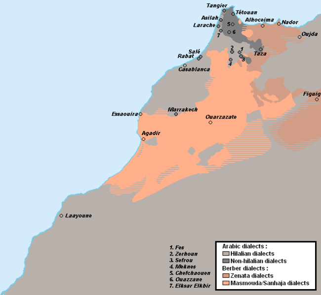
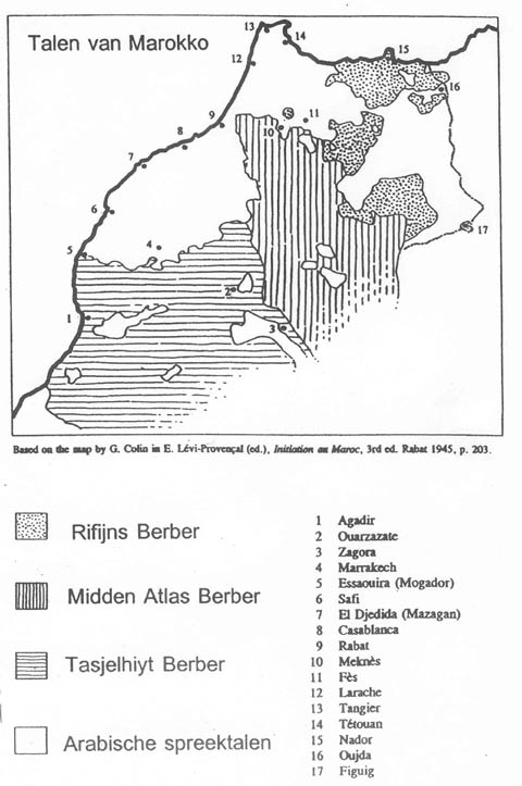
Beschrijving
| Beschrijving |
English: Linguistic map of Morocco, map drawn acc. to:
|
| Datum | 18 juli 2012 (originele uploaddatum) |
| Bron |
Eigen werk Own made map |
| Auteur | Omar-Toons |
| Andere versies |
 |
Licentie
Omar-Toons op de Engelstalige Wikipedia, de auteursrechthebbende van dit werk, maakt het hierbij onder de volgende licenties beschikbaar:

|
Toestemming wordt verleend voor het kopiëren, verspreiden en/of wijzigen van dit document onder de voorwaarden van de GNU-licentie voor vrije documentatie, versie 1.2 of enige latere versie als gepubliceerd door de Free Software Foundation; zonder Invariant Sections, zonder Front-Cover Texts, en zonder Back-Cover Texts. Een kopie van de licentie is opgenomen in de sectie GNU-licentie voor vrije documentatie. |
Dit bestand is gelicenseerd onder de Creative Commons-licentie Naamsvermelding-Gelijk delen 3.0 Unported
Naamsvermelding: Omar-Toons op de Engelstalige Wikipedia
- De gebruiker mag:
- Delen – het werk kopiëren, verspreiden en doorgeven
- Remixen – afgeleide werken maken
- Onder de volgende voorwaarden:
- naamsvermelding – U moet op een gepaste manier aan naamsvermelding doen, een link naar de licentie geven, en aangeven of er wijzigingen in het werk zijn aangebracht. U mag dit op elke redelijke manier doen, maar niet zodanig dat de indruk wordt gewekt dat de licentiegever instemt met uw werk of uw gebruik van zijn werk.
- Gelijk delen – Als u het werk heeft geremixt, veranderd, of erop heeft voortgebouwd, moet u het gewijzigde materiaal verspreiden onder dezelfde licentie als het oorspronkelijke werk, of een daarmee compatibele licentie.
U mag zelf één van de licenties kiezen.
Oorspronkelijk uploadlogboek
Verplaatst vanaf en.wikipedia naar Commons door Omar-toons met behulp van CommonsHelper.
De oorspronkelijke beschrijving van deze afbeelding stond hier. Alle volgende gebruikersnamen verwijzen naar en.wikipedia.
- 2012-07-19 17:19 Omar-Toons 652×601× (22351 bytes) Uploading a self-made file using [[Wikipedia:File_Upload_Wizard|File Upload Wizard]]
Bestandsgeschiedenis
Klik op een datum/tijd om het bestand te zien zoals het destijds was.
| Datum/tijd | Miniatuur | Afmetingen | Gebruiker | Opmerking | |
|---|---|---|---|---|---|
| huidige versie | 10 dec 2019 11:19 | | 652 × 601 (19 kB) | Omar-toons | Mod. Arabic-speaking areas Bhalil + Fechtala + More precise limits for Warayn & Seghrouchen |
| 20 nov 2013 06:12 |  | 652 × 601 (22 kB) | Omar-toons | Corr. Essaouira's location | |
| 15 dec 2012 05:32 |  | 652 × 601 (22 kB) | Omar-toons | {{Information |Description={{en|Linguistic map of Morocco}} |Source= Own made map |Date={{Original upload date|2012-07-18}}<br/> ({{Original upload date|2012-07-19}}) |Author=Omar-Toons. Original uploader was {{user at project|O... |
Bestandsgebruik
Geen enkele pagina gebruikt dit bestand.
Globaal bestandsgebruik
De volgende andere wiki's gebruiken dit bestand:
- Gebruikt op ar.wikipedia.org
- Gebruikt op ary.wikipedia.org
- Gebruikt op arz.wikipedia.org
- Gebruikt op ca.wikipedia.org
- Gebruikt op da.wikipedia.org
- Gebruikt op en.wikipedia.org
- Gebruikt op es.wikipedia.org
- Gebruikt op fr.wikipedia.org
- Gebruikt op io.wikipedia.org
- Gebruikt op it.wikipedia.org
- Gebruikt op mt.wikipedia.org
- Gebruikt op nl.wikipedia.org
- Gebruikt op no.wikipedia.org
- Gebruikt op shi.wikipedia.org
- Gebruikt op simple.wikipedia.org
- Gebruikt op si.wikipedia.org
- Gebruikt op tr.wikipedia.org
- Gebruikt op tum.wikipedia.org
- Gebruikt op ur.wikipedia.org