
Bestand:Rail transport infrastructure map - UK - South East England.svg

Oorspronkelijk bestand (SVG-bestand, nominaal 1.247 × 983 pixels, bestandsgrootte: 8,83 MB)
Dit is een bestand van Wikimedia Commons. Onderstaande beschrijving komt van de beschrijving van het bestand daar.
Commons is een vrij-gelicenceerde database voor afbeeldingen, geluid, video en andere bestanden. |
Beschrijving
| Beschrijving |
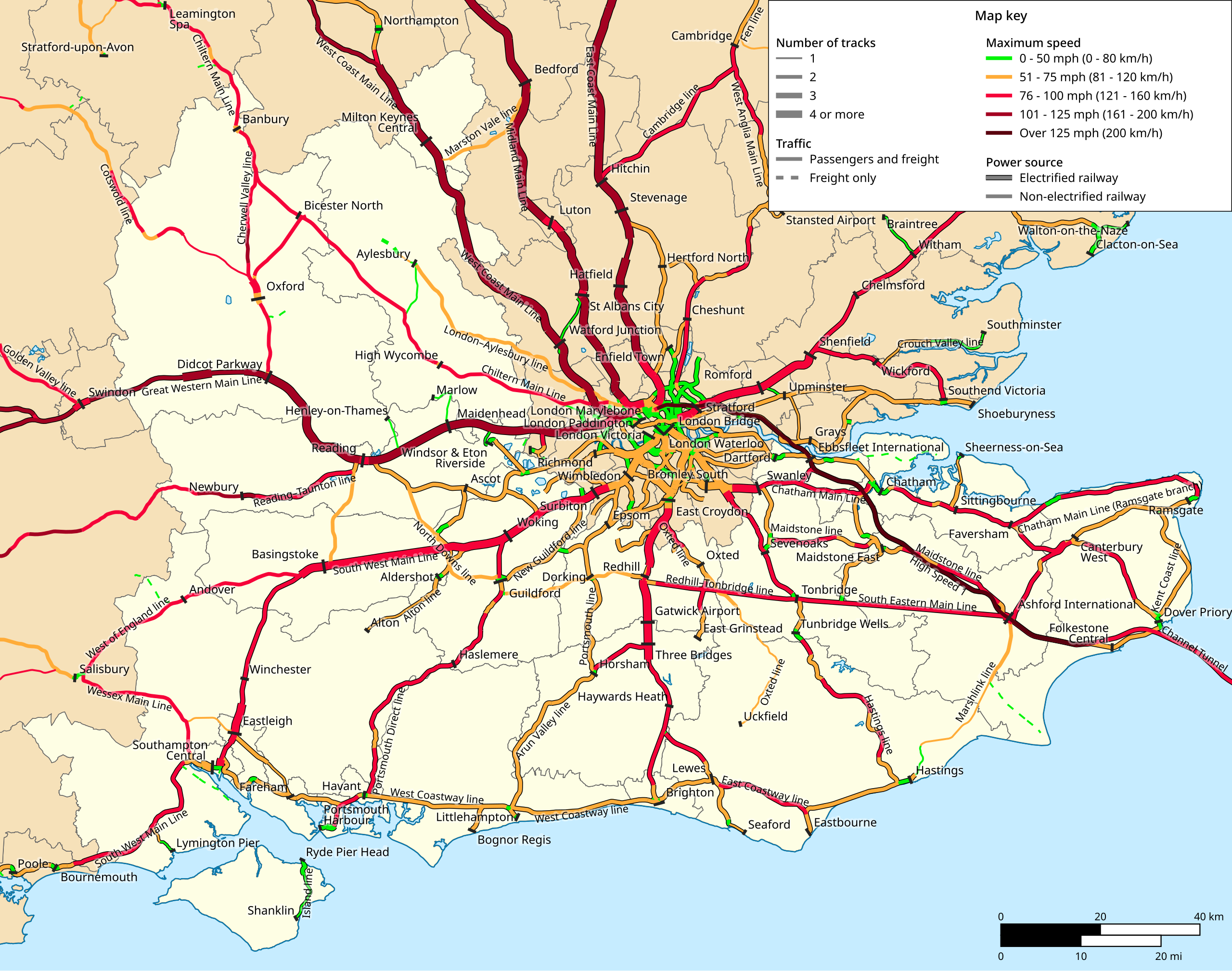
Français : Carte géographiquement exacte des infrastructures ferroviaires de la région de South East England (Royaume-Uni), en 2024.
English: Geographically correct rail transport infrastructure map of South East England (United Kingdom), as of 2024. |
| Datum | |
| Bron | Eigen werk |
| Auteur | Benjamin Smith |
English: About represented data
|
|---|
|
This map shows all railways owned by Network Rail, as well as some railways not owned by Network Rail but dedicated to long-distance travel and with technical similarities to Network Rail lines (ex. Channel Tunnel, Crossrail, etc). It does not show urban rail transit such as tram or underground lines. It noes not show closed or dismantled railways either. On any particular railway section, speed limit shown on this map is the highest of all tracks, of both directions and of all types of trains allowed on this section. Although all tracks may not be electrified on multiple-track lines, a railway section is shown as electrified as long as at least one track is electrified. Short distance changes in the number of tracks or speed limit, as typically encountered near railway stations, junctions, sharp curves, bridges and tunnels, are not shown if they are approximately under 2 km or 1 mi. For the sake of readability, this map may take into account the total number of tracks on certain common trunks whereas these are operated as several independent lines. |
Français : Précisions sur les données représentées
|
|---|
|
Cette carte montre toutes les lignes de chemin de fer propriété du gestionnaire d'infrastructure britannique Network Rail, ainsi que quelques lignes dédiées au trafic de longue distance et possédant des caractéristiques techniques similaires (Tunnel sous la Manche, Crossrail, etc). Les lignes de tramway, métro, etc, ne sont pas représentées, de même que les lignes fermées ou déclassées. La vitesse maximale représentée pour un tronçon de ligne est toujours celui de la voie la plus rapide, dans la direction la plus rapide, pour le type de trains le plus rapide parmi ceux autorisés sur la ligne. Une section de ligne est représentée comme électrifiée dès lors qu'au moins une voie est électrifiée. Les changements de courte distance dans le nombre de voies ou la vitesse maximale autorisée (notamment à la traversée de certaines gares, à des jonctions, dans des courbes de faible rayon, sur des ponts ou des tunnels) ne sont pas représentés si leur longueur est inférieure à 2 km ou 1 mi approximativement. Par souci de lisibilité, cette carte peut prendre en compte le nombre total de voies de certains troncs communs alors que ceux-ci sont exploités comme plusieurs lignes indépendantes. |
| Sources |
|---|
|
The information contained in this map is mainly based on: Despite all the care that has been taken in producing this map, errors may have introduced. I welcome any information that could help to correct or refine certain elements of this map. |
Licentie

|
Toestemming wordt verleend voor het kopiëren, verspreiden en/of wijzigen van dit document onder de voorwaarden van de GNU-licentie voor vrije documentatie, versie 1.2 of enige latere versie als gepubliceerd door de Free Software Foundation; zonder Invariant Sections, zonder Front-Cover Texts, en zonder Back-Cover Texts. Een kopie van de licentie is opgenomen in de sectie GNU-licentie voor vrije documentatie. |
- De gebruiker mag:
- Delen – het werk kopiëren, verspreiden en doorgeven
- Remixen – afgeleide werken maken
- Onder de volgende voorwaarden:
- naamsvermelding – U moet op een gepaste manier aan naamsvermelding doen, een link naar de licentie geven, en aangeven of er wijzigingen in het werk zijn aangebracht. U mag dit op elke redelijke manier doen, maar niet zodanig dat de indruk wordt gewekt dat de licentiegever instemt met uw werk of uw gebruik van zijn werk.
- Gelijk delen – Als u het werk heeft geremixt, veranderd, of erop heeft voortgebouwd, moet u het gewijzigde materiaal verspreiden onder dezelfde licentie als het oorspronkelijke werk, of een daarmee compatibele licentie.
Although this is not compulsory, I'm always glad to read that my work is useful to others. If you could send me an e-mail at benji dot wiki at gmail dot com to inform me that you are using my work, I'd be delighted. Thanks a lot!
Envie d'utiliser cette image en dehors des projets Wikimedia ? N'hésitez pas ! Cette image est placée sous licence libre de façon à ce que vous puissiez l'utiliser librement, sans avoir besoin d'une autorisation de ma part. Tout ce que vous devez faire, c'est respecter les termes de la licence et me créditer ainsi :
Bien que ce ne soit pas obligatoire, je suis toujours ravi d'apprendre que mon travail a été utile à d'autres. Si vous pouviez m'envoyer un courriel à benji point wiki arobase gmail point com pour m'informer du fait que vous utilisez mon travail, ce serait top. Merci d'avance !
Bestandsgeschiedenis
Klik op een datum/tijd om het bestand te zien zoals het destijds was.
| Datum/tijd | Miniatuur | Afmetingen | Gebruiker | Opmerking | |
|---|---|---|---|---|---|
| huidige versie | 16 mrt 2024 17:06 | | 1.247 × 983 (8,83 MB) | Benjism89 | File uploaded using svgtranslate tool (https://svgtranslate.toolforge.org/). Added translation for fr. |
| 16 mrt 2024 16:40 |  | 1.247 × 983 (8,99 MB) | Benjism89 | Uploaded a work by Benjamin Smith from {{own}} with UploadWizard |
Bestandsgebruik
Dit bestand wordt op de volgende pagina gebruikt:
Globaal bestandsgebruik
De volgende andere wiki's gebruiken dit bestand:
- Gebruikt op de.wikivoyage.org
- Gebruikt op el.wikivoyage.org
- Gebruikt op en.wikipedia.org
- Gebruikt op en.wikivoyage.org
- Gebruikt op es.wikipedia.org
- Gebruikt op fr.wikivoyage.org
- Gebruikt op it.wikivoyage.org
- Gebruikt op www.wikidata.org