
Bestand:Sea-of-Okhotsk-Full-Map-Hokkaido-Kuril-Kamchatka-Sakhalin.png

Grootte van deze voorvertoning: 800 × 547 pixels. Andere resoluties: 320 × 219 pixels | 640 × 438 pixels | 1.024 × 700 pixels | 1.280 × 875 pixels | 2.560 × 1.751 pixels | 5.188 × 3.548 pixels.
Oorspronkelijk bestand (5.188 × 3.548 pixels, bestandsgrootte: 14,83 MB, MIME-type: image/png)
Dit is een bestand van Wikimedia Commons. Onderstaande beschrijving komt van de beschrijving van het bestand daar.
Commons is een vrij-gelicenceerde database voor afbeeldingen, geluid, video en andere bestanden. |
Beschrijving
| Beschrijving |
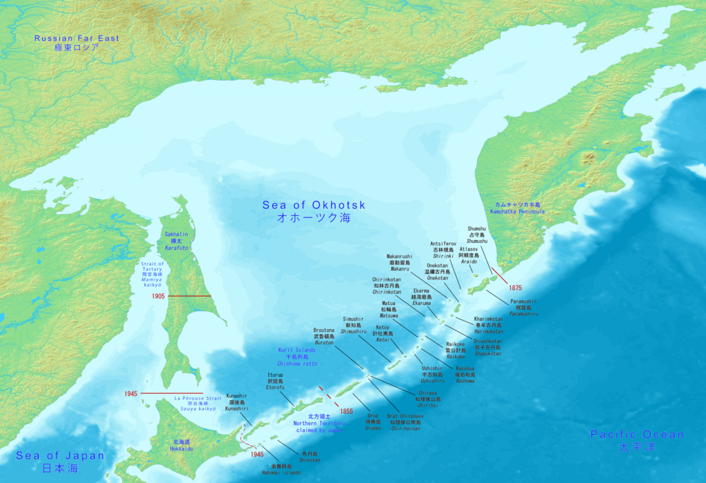
English: Big map has the full Sea of Okhotsk with Hokkaido, Kuril islands, Kamchatka peninsula and Sakhalin (Karafuto). It includes the Japanese and Russian names with English.
日本語: 大きな地図には、北海道、千島列島、カムチャッカ半島、サハリン(樺太)を含むオホーツク海全体が表示されます。 日本語とロシア語の名前と英語が含まれています。
Русский: Большая карта имеет полное Охотское море с Хоккайдо, Курильскими островами, полуостровом Камчатка и Сахалином (Карафуто). В него входят японские и русские названия с английскими. |
| Datum | |
| Bron | Made with DEMIS World Map Server https://www.demis.nl/products/web-map-server/examples |
| Auteur | DEMIS World Map Server, Artanisen |
| Andere versies |
|

Licentie
| Dit bestand is beschikbaar onder Creative Commons CC0 1.0 Universele Public Domain Dedication. | |
| De persoon die een werk voorziet van deze licentie stelt dit werk beschikbaar aan het publieke domein door, voor zover dit wettelijk is toegestaan, afstand te doen van alle rechten op het werk in de zin van het auteursrecht, met inbegrip van alle aanverwante of naburige rechten. U kunt het werk kopiëren, aanpassen, distribueren en uitvoeren, ook voor commerciële doeleinden, zonder dat u daarvoor toestemming hoeft te vragen.
|
Bestandsgeschiedenis
Klik op een datum/tijd om het bestand te zien zoals het destijds was.
| Datum/tijd | Miniatuur | Afmetingen | Gebruiker | Opmerking | |
|---|---|---|---|---|---|
| huidige versie | 17 jun 2020 17:10 | | 5.188 × 3.548 (14,83 MB) | Artanisen | Corrected Japanese spelling: オホーツク海 |
| 17 jun 2020 02:37 |  | 5.188 × 3.548 (14,83 MB) | Artanisen | Fixed letter font of Shumshu. | |
| 16 jun 2020 18:44 |  | 5.188 × 3.548 (14,83 MB) | Artanisen | Updated to show the full Sea of Okhotsk with a big detailed map. It includes the Japanese and Russian names with standard English translations. | |
| 13 jun 2020 23:00 |  | 3.280 × 2.144 (2,24 MB) | Artanisen | Uploaded a work by DEMIS World Map Server, Artanisen from https://www.demis.nl/products/web-map-server/examples with UploadWizard |
Bestandsgebruik
Geen enkele pagina gebruikt dit bestand.
Globaal bestandsgebruik
De volgende andere wiki's gebruiken dit bestand:
- Gebruikt op ca.wikipedia.org
- Gebruikt op en.wikipedia.org
- Gebruikt op ky.wikipedia.org
- Gebruikt op sl.wikipedia.org
- Gebruikt op sr.wikipedia.org