
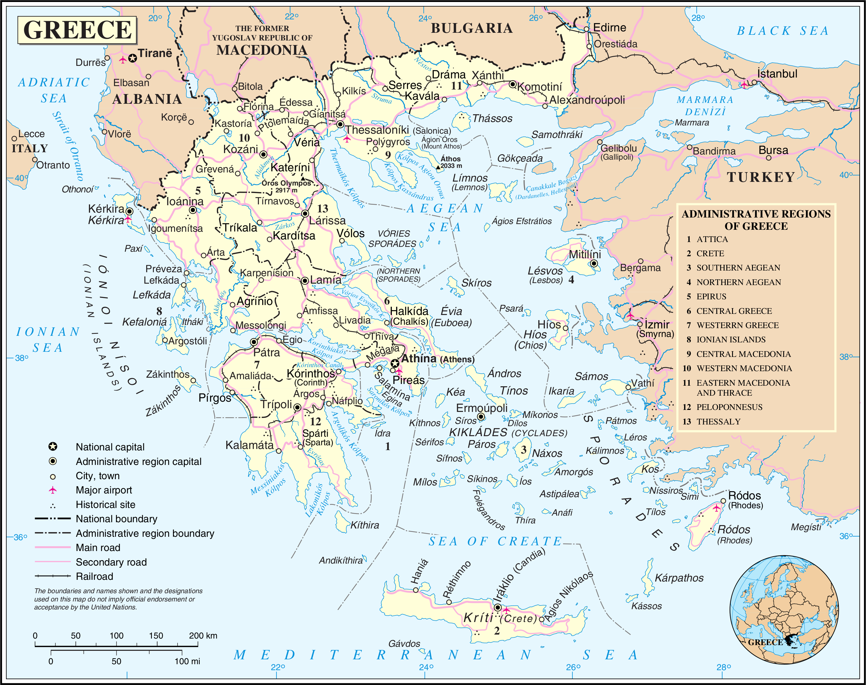
Bestand:Un-greece.png
Oorspronkelijk bestand (3.039 × 2.403 pixels, bestandsgrootte: 2,05 MB, MIME-type: image/png)
Dit is een bestand van Wikimedia Commons. Onderstaande beschrijving komt van de beschrijving van het bestand daar.
Commons is een vrij-gelicenceerde database voor afbeeldingen, geluid, video en andere bestanden. |
| This image is a map derived from a United Nations map.
Unless stated otherwise, UN maps are to be considered in the public domain. This applies worldwide. UN maps are, in principle, open source material and you can use them in your work or for making your own map. UN requests however that you delete the UN name, logo and reference number upon any modification to the map. Content of your map will be your responsibility. You can state in your publication, if you wish, something like: based on UN map … (map name, map number, revision number and date). See: Geospatial Information Section. And: Geospatial, location data for a better world. |
 |
Bestandsgeschiedenis
Klik op een datum/tijd om het bestand te zien zoals het destijds was.
| Datum/tijd | Miniatuur | Afmetingen | Gebruiker | Opmerking | |
|---|---|---|---|---|---|
| huidige versie | 24 okt 2007 02:04 | | 3.039 × 2.403 (2,05 MB) | Jeroen | {{UN map}} Category:Maps of Greece |
Bestandsgebruik
Dit bestand wordt op de volgende pagina gebruikt:
Globaal bestandsgebruik
De volgende andere wiki's gebruiken dit bestand:
- Gebruikt op bn.wikipedia.org
- Gebruikt op de.wikipedia.org
- Gebruikt op de.wikinews.org
- Gebruikt op en.wikipedia.org
- Gebruikt op fa.wikipedia.org
- Gebruikt op id.wikipedia.org
- Gebruikt op ku.wikipedia.org
- Gebruikt op lt.wikipedia.org
- Gebruikt op nl.wikipedia.org
- Gebruikt op pl.wiktionary.org
- Gebruikt op sq.wikinews.org
- Gebruikt op vi.wikipedia.org
- Gebruikt op www.wikidata.org