
Bestand:Occupation borders in Slovenia 1941-1945. Border lines and occupied territories.tif

Oorspronkelijk bestand (3.094 × 2.185 pixels, bestandsgrootte: 19,34 MB, MIME-type: image/tiff)
Dit is een bestand van Wikimedia Commons. Onderstaande beschrijving komt van de beschrijving van het bestand daar.
Commons is een vrij-gelicenceerde database voor afbeeldingen, geluid, video en andere bestanden. |
Beschrijving
| Beschrijving |
English: historical map |
| Datum | |
| Bron |
The map is the result of work on the research project Make me this German-Italian-Hungarian-Croatian country! The role of occupation borders in denationalization policy and the life of the Slovenian population. (Funded by ARRS J6-8248). The project was implemented by Kornelija Ajlec, Bojan Balkovec, Rok Ciglič, Božidar Flajšman, Aleš Gabrič, Primož Gašperič, Bojan Godeša, Darja Kerec, Attila Kovacs, Peter Mikša, Božo Repe (manager), Maja Vehar, Manca Volk Bahun, Matija Zorn. Authors allow publication. https://okupacijnemeje.si/exh01-ch02.html |
| Auteur | Manca Volk Bahun, Rok Ciglič, Matija Zorn |
| Toestemming (Hergebruik van dit bestand) |
Licentie
- De gebruiker mag:
- Delen – het werk kopiëren, verspreiden en doorgeven
- Remixen – afgeleide werken maken
- Onder de volgende voorwaarden:
- naamsvermelding – U moet op een gepaste manier aan naamsvermelding doen, een link naar de licentie geven, en aangeven of er wijzigingen in het werk zijn aangebracht. U mag dit op elke redelijke manier doen, maar niet zodanig dat de indruk wordt gewekt dat de licentiegever instemt met uw werk of uw gebruik van zijn werk.
- Gelijk delen – Als u het werk heeft geremixt, veranderd, of erop heeft voortgebouwd, moet u het gewijzigde materiaal verspreiden onder dezelfde licentie als het oorspronkelijke werk, of een daarmee compatibele licentie.
Bestandsgeschiedenis
Klik op een datum/tijd om het bestand te zien zoals het destijds was.
| Datum/tijd | Miniatuur | Afmetingen | Gebruiker | Opmerking | |
|---|---|---|---|---|---|
| huidige versie | 29 mei 2023 12:07 | 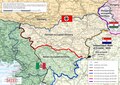 | 3.094 × 2.185 (19,34 MB) | Bb63lj | Uploaded a work by Manca Volk Bahun, Rok Ciglič, Matija Zorn from The map is the result of work on the research project Make me this German-Italian-Hungarian-Croatian country! The role of occupation borders in denationalization policy and the life of the Slovenian population. (Funded by ARRS J6-8248). The project was implemented by Kornelija Ajlec, Bojan Balkovec, Rok Ciglič, Božidar Flajšman, Aleš Gabrič, Primož Gašperič, Bojan Godeša, Darja Kerec, Attila Kovacs, Peter Mikša, Božo Repe (mana... |
Bestandsgebruik
Geen enkele pagina gebruikt dit bestand.
Globaal bestandsgebruik
De volgende andere wiki's gebruiken dit bestand:
- Gebruikt op bs.wikipedia.org
- Gebruikt op en.wikipedia.org
- Gebruikt op fr.wikipedia.org
- Gebruikt op mk.wikipedia.org